Adobe’s eXtensible Metadata Platform (XMP) is a labeling technology that allows you to embed data about a file, known as metadata, into the file itself.
In the context of 360 videos and photos, XMP can be used to define location information, equipment used to shoot, times of capture, and much more… as you’ll see in this post.
However, it’s important to realise XMP is used far beyond the world of image and video files. PDF’s for example, where XMP can contain titles and descriptions, searchable keywords, and up-to-date author and copyright information.
As an open source technology, it is freely available to developers. You can browse the full specification here.
An XMP namespaces defines a set of properties (tags).
Think of a namespace like a standard for a specific use.
For example, the XMP-Device namespace contains Google depth-map Device tags (see this page for the namespace specification. These are tags like CameraImagingModel and CameraDepthMap, as well as many other very useful for augmented reality applications.

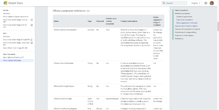
Source: https://developers.google.com/streetview/spherical-metadata
Or for 360 photos, the XMP-GPano is a namespace used for panorama photo tags written by Google Photosphere (see this page for the namespace specification. In this namespace you will find tags like PoseHeadingDegrees and FullPanoHeightPixels used for rendering 360 photos properly.
Here’s an example of XMP-GPano, GPS, and IFD0 namespace tags from my post last year, A deeper look into a 360 photo and the metadata it holds.
CLI:
$ exiftool -X MULTISHOT_8302_000052.jpg > MULTISHOT_8302_000052_metadata.txt
Output (cropped):
<?xml version='1.0' encoding='UTF-8'?>
[...]
<IFD0:ImageWidth>5760</IFD0:ImageWidth>
<IFD0:ImageHeight>2880</IFD0:ImageHeight>
<IFD0:Make>GoPro</IFD0:Make>
<IFD0:Model>GoPro Fusion FS1.04.01.80.00</IFD0:Model>
<IFD0:Software>GoPro Fusion Studio 1.3.0.400</IFD0:Software>
<IFD0:ModifyDate>2020:02:05 20:20:33</IFD0:ModifyDate>
<IFD0:Artist>https://www.trekview.org</IFD0:Artist>
<IFD0:Copyright>https://www.trekview.org</IFD0:Copyright>
<ExifIFD:DateTimeOriginal>2020:02:05 10:38:26</ExifIFD:DateTimeOriginal>
<ExifIFD:UserComment>Please contact [email protected] if you want to use this photograph commercially.</ExifIFD:UserComment>
<GPS:GPSLatitudeRef>North</GPS:GPSLatitudeRef>
<GPS:GPSLatitude>28 deg 21' 0.60"</GPS:GPSLatitude>
<GPS:GPSLongitudeRef>West</GPS:GPSLongitudeRef>
<GPS:GPSLongitude>16 deg 54' 13.88"</GPS:GPSLongitude>
<GPS:GPSAltitudeRef>Above Sea Level</GPS:GPSAltitudeRef>
<GPS:GPSAltitude>467.03 m</GPS:GPSAltitude>
<GPS:GPSTimeStamp>10:32:38</GPS:GPSTimeStamp>
<GPS:GPSDateStamp>2020:02:05</GPS:GPSDateStamp>
<XMP-x:XMPToolkit>XMP Core 4.4.0-Exiv2</XMP-x:XMPToolkit>
<XMP-GPano:StitchingSoftware>GoPro Fusion Studio 1.3.0.400</XMP-GPano:StitchingSoftware>
<XMP-GPano:SourcePhotosCount>2</XMP-GPano:SourcePhotosCount>
<XMP-GPano:UsePanoramaViewer>True</XMP-GPano:UsePanoramaViewer>
<XMP-GPano:ProjectionType>equirectangular</XMP-GPano:ProjectionType>
<XMP-GPano:CroppedAreaImageHeightPixels>2880</XMP-GPano:CroppedAreaImageHeightPixels>
<XMP-GPano:CroppedAreaImageWidthPixels>5760</XMP-GPano:CroppedAreaImageWidthPixels>
<XMP-GPano:FullPanoHeightPixels>2880</XMP-GPano:FullPanoHeightPixels>
<XMP-GPano:FullPanoWidthPixels>5760</XMP-GPano:FullPanoWidthPixels>
<XMP-GPano:CroppedAreaLeftPixels>0</XMP-GPano:CroppedAreaLeftPixels>
<XMP-GPano:CroppedAreaTopPixels>0</XMP-GPano:CroppedAreaTopPixels>
<Composite:ImageSize>5760x2880</Composite:ImageSize>
<Composite:Megapixels>16.6</Composite:Megapixels>
<Composite:GPSAltitude>467 m Above Sea Level</Composite:GPSAltitude>
<Composite:GPSDateTime>2020:02:05 10:32:38Z</Composite:GPSDateTime>
<Composite:GPSLatitude>28 deg 21' 0.60" N</Composite:GPSLatitude>
<Composite:GPSLongitude>16 deg 54' 13.88" W</Composite:GPSLongitude>
<Composite:GPSPosition>28 deg 21' 0.60" N, 16 deg 54' 13.88" W</Composite:GPSPosition>
</rdf:Description>
</rdf:RDF>
In the world of 360 videos, XMP-GSpherical is the most widely adopted standard. Strictly speaking this is not actually XMP data.
XMP-GSpherical are written into the video track of MOV/MP4 files, and not at the top level like other XMP tags (see this page for the namespace specification. They are RDF/XML tags, for example:
<rdf:SphericalVideo
  xmlns:rdf="http://www.w3.org/1999/02/22-rdf-syntax-ns#"
  xmlns:GSpherical="http://ns.google.com/videos/1.0/spherical/">
  <GSpherical:Spherical>true</GSpherical:Spherical>
  <GSpherical:Stitched>true</GSpherical:Stitched>
  <GSpherical:StitchingSoftware>
    OpenCV for Windows v2.4.9
  </GSpherical:StitchingSoftware>
  <GSpherical:ProjectionType>equirectangular</GSpherical:ProjectionType>
  <GSpherical:SourceCount>6</GSpherical:SourceCount>
  <GSpherical:InitialViewHeadingDegrees>90</GSpherical:InitialViewHeadingDegrees>
  <GSpherical:InitialViewPitchDegrees>0</GSpherical:InitialViewPitchDegrees>
  <GSpherical:InitialViewRollDegrees>0</GSpherical:InitialViewRollDegrees>
  <GSpherical:Timestamp>1400454971</GSpherical:Timestamp>
  <GSpherical:CroppedAreaImageWidthPixels>
    1920
  </GSpherical:CroppedAreaImageWidthPixels>
  <GSpherical:CroppedAreaImageHeightPixels>
    1080
  </GSpherical:CroppedAreaImageHeightPixels>
  <GSpherical:FullPanoWidthPixels>1900</GSpherical:FullPanoWidthPixels>
  <GSpherical:FullPanoHeightPixels>960</GSpherical:FullPanoHeightPixels>
  <GSpherical:CroppedAreaLeftPixels>15</GSpherical:CroppedAreaLeftPixels>
  <GSpherical:CroppedAreaTopPixels>60</GSpherical:CroppedAreaTopPixels>
</rdf:SphericalVideo>
XMP vs. EXIF
You might have also noticed XMP-exif in the XMP specification.
It’s important to point out, the XMP-exif namespace differs from the EXIF data standard developed by CIPA.
See the exiftool list of tags for an easy way to understand the differences.
EXIF is another standard (like XMP) designed for image and sound files, whereas XMP covers a much broader spectrum of file types.
XMP is also broader in the tags that can be used because of the namespaces that have been developed. The EXIF standard on the other hand is a closed specification with a defined number of tags. The upside being of having a single namespace is that the standard is widely understood by other products (some more niche XMP namespaces are not).
You can see the full EXIF standard and available tags here.
Writing XMP tags to files
Using EXIFtool it’s possible to write XMP data into photo, image and video files, in addition to EXIF data.
For example, lets say I wanted to write to the XMP-GPano namespace with the tag ProjectionType for a photo:
exiftool -XMP-GPano:ProjectionType=equirectangular my_photo.jpg
It’s likely I would want to add more than one XMP-GPano tag. Doing this is easy, like so:
exiftool -XMP-GPano:FullPanoHeightPixels=2880 -XMP-GPano:FullPanoHeightWidth=5760 -XMP-GPano:StitchingSoftware='exiftool' my_photo.jpg
A note on XMP-GSpherical tags in videos
As I mentioned earlier, XMP-GSpherical is not really XMP. As such, exiftool is unable to write these tags into video files. If you’re working with 360 video files, you will need to use another way.
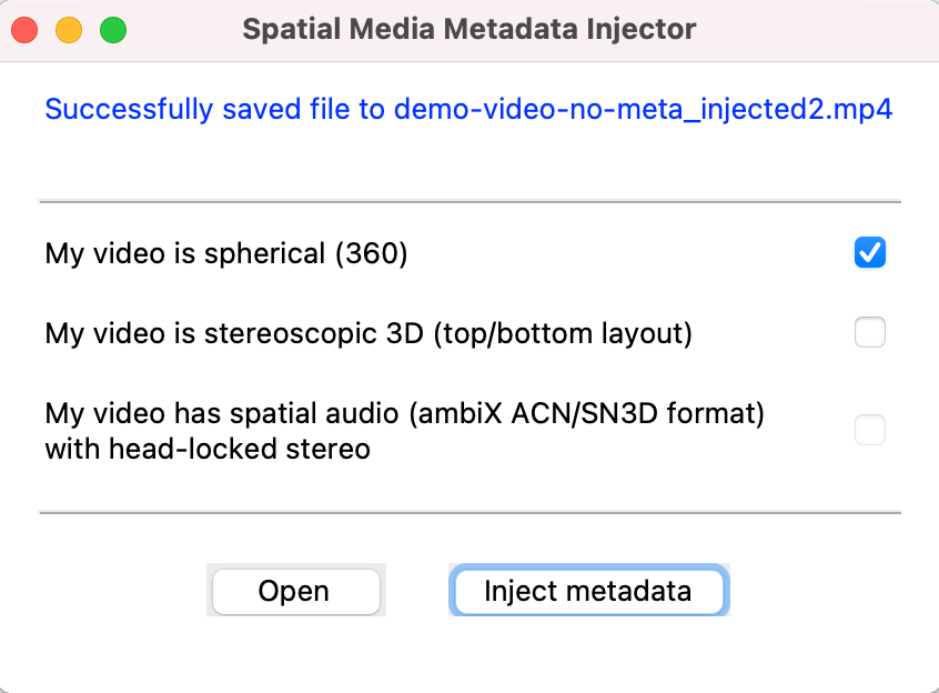
Luckily Google has created a Python script for injecting required XMP-GSpherical metadata tags into videos, the Spatial Media Metadata Injector.

You can run the Spatial Media Metadata Injector’s simple interface once you’ve cloned the repo:
$ git clone https://github.com/google/spatial-media.git
$ cd spatialmedia
$ python gui.py
Selecting “My video is spherical (360)” will add the following tags:
Spherical = true
Stitched = true
StitchingSoftware = Spherical Metadata Tool
ProjectionType = equirectangular
There is the option to inject via the command line too:
python spatialmedia -i demo-video-no-meta.mp4 demo-video-with-meta.mp4
We're building a Street View alternative for explorers
If you'd like to be the first to receive monthly updates about the project, subscribe to our newsletter...


